|
CyanoAlert helps you to address water quality concerns by analysing satellite images and automatically delivering tailored results and notifications via a simple-to-use web interface and app.
CyanoAlert is a web based global service that automatically delivers up-to-date and historical water quality information based on analysis of satellite images, both user-specific information to paying customers and free and open information to the public.
The service offers information on cyanobacteria blooms, eutrophication (chlorophyll-a) and supplementary water quality products through its web portal, viewer and mobile app.
CyanoAlert is directed towards all people interested in the status of water bodies and monitoring of water quality. CyanoAlert is especially useful for those working for environmental authorities and in the commercial sector who are concerned by health risks and quality of water resources and in charge of activities for improvement. The general public who would like to avoid being affected by toxic algal blooms can also benefit from the CyanoAlert service and explore where it might unsafe or unpleasant to swim, go boating or walk the dog.
Customers can easily get an overview of water quality status, monitor changes, tailor actions and receive customized results and reports. Potential risks to livestock, fish and mollusc farming and aquatic ecosystems can be evaluated and alerts issued to responsible stakeholders.
Based on the service, on-going monitoring efforts can become significantly more effective. CyanoAlert gives you water quality information for entire water bodies on all cloud free days and helps you to more effectively plan where and when to take water samples for analysis. The service can add value and bring new knowledge to traditional field sampling efforts and put scarce field samples in to context. The service aims to increase the general awareness on the status of our waters by providing map alerts and information for free to the public and asking for their help to give feedback in real time via the app. The feedback will help to further improve the service.
CyanoAlert can help us all to change the way water quality is monitored around the globe to more efficiently address emergency, security and climate change concerns and support UN’s vision for a more sustainable future for all.
Assess water quality status and risk areas using the CyanoAlert Viewer.
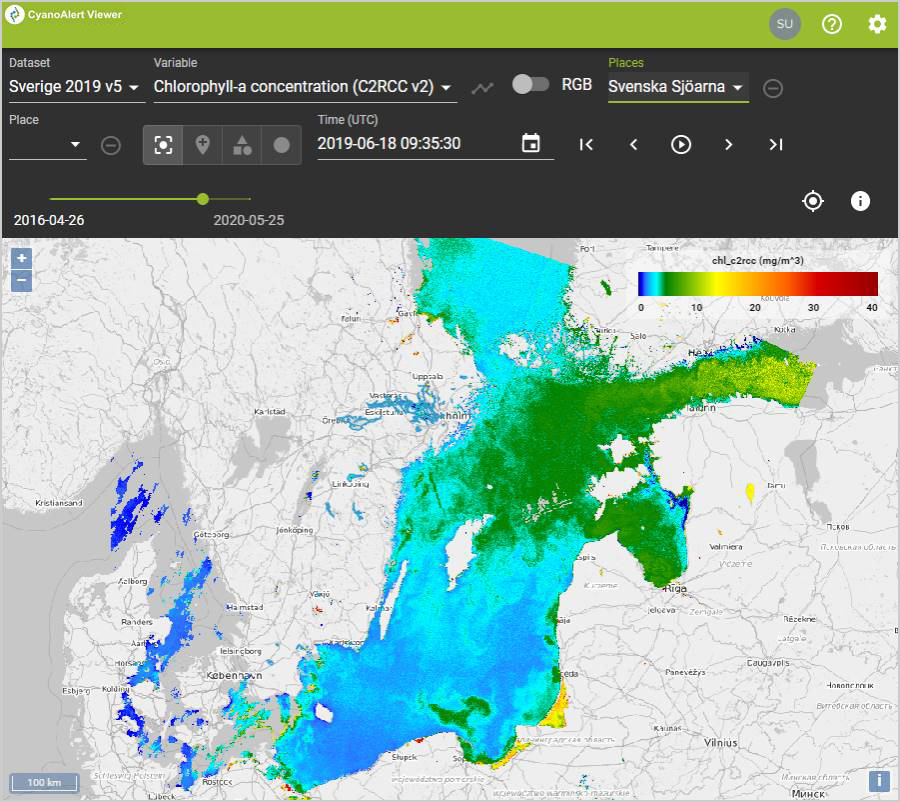
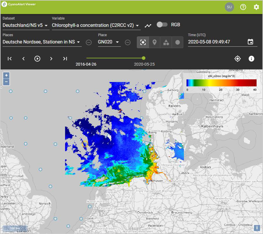
Use the web based CyanoAlert Viewer to analyse and view near-real time satellite images and maps of water quality parameters for your areas of interest.
 |
 |
 |
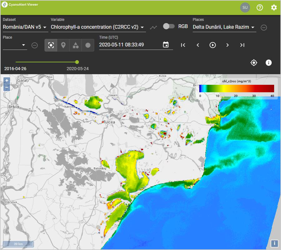 |
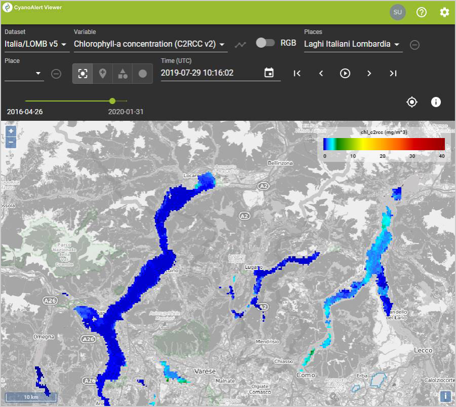
CyanoAlert Viewer, examples of four user defined locations in Europe.
Check the "immersed Cyanobacteria indicator" in the CyanoAlert Viewer!
 |
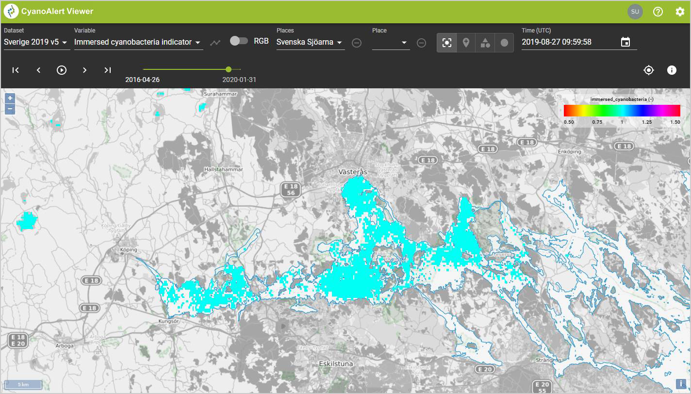 |
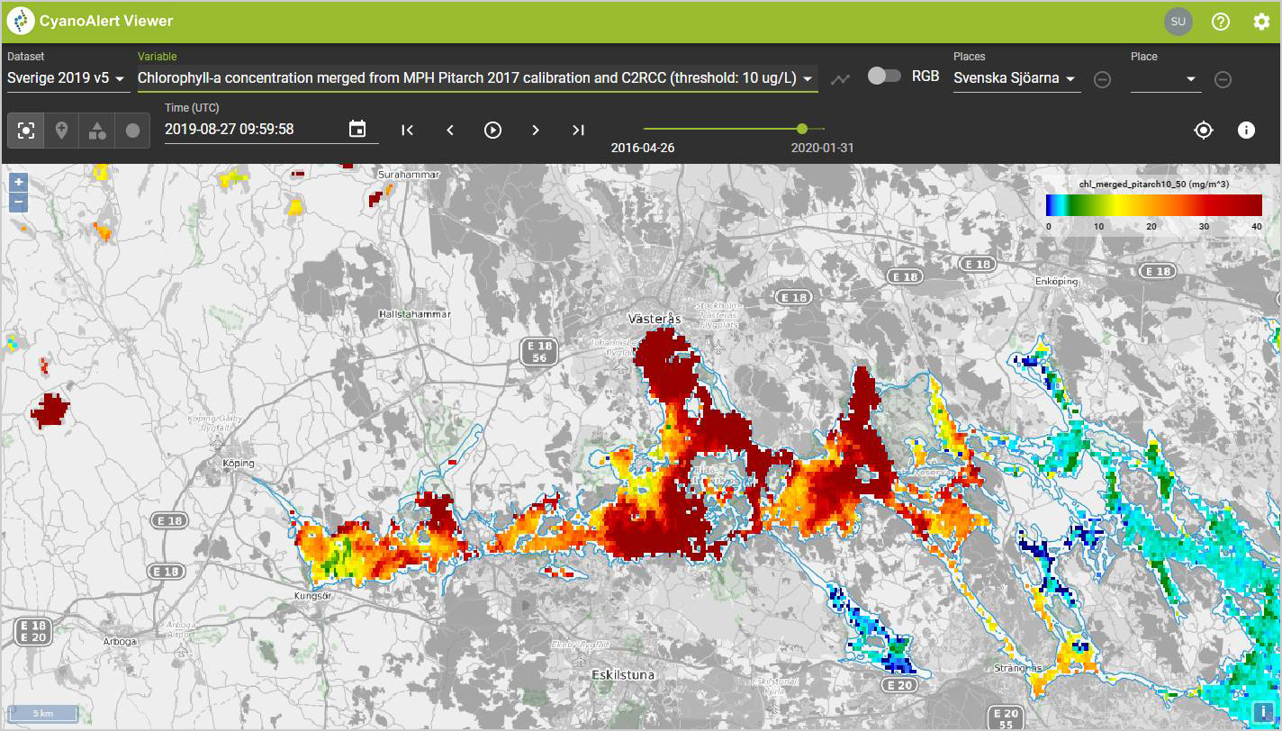
The CyanoAlert Viewer showing maps of Chlorophyll-a concentration (left) and the detection of potentially toxic cyanobacteria in the water (right) from August 27, 2019, for the western end of Lake Mälaren, Sweden.
Using the Viewer, you can also view graphs and zoom in on relevant time intervals for your applications. Let recent and historical information help guide mitigation activities and set priorities.
Choose a pre-defined waterbody or create new points, polygons and circles.
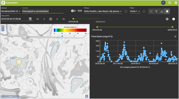
Time series of Chlorophyll-a for a user defined Circle (yellow) in Lake Isac, Danube Delta, Romania. The blue polygons are lake water bodies, pre-defined by the User of the service, and available for time series analysis.
Receive alerts for your own selection of monitoring stations, bathing sites, coastal areas or lakes.
The CyanoAlert Users defines their own locations or areas of interest for which satellite based water quality information is generated and delivered to the user in near real time.
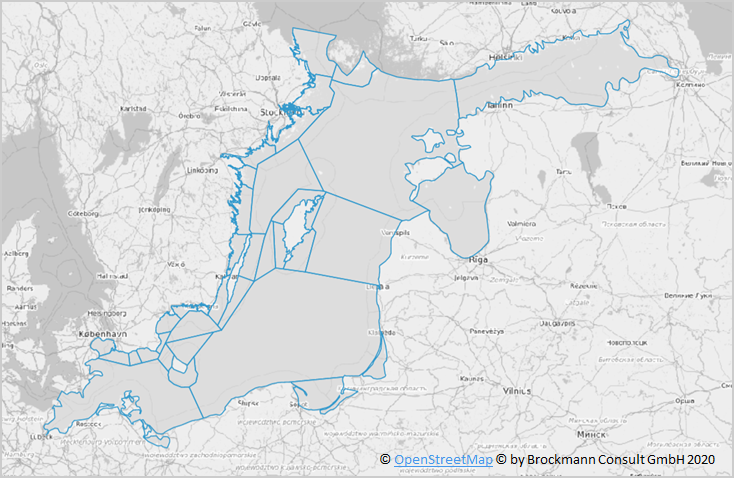
User defined areas of the Baltic Proper for near real time monitoring of algal blooms.
CyanoAlert users can set alert criteria and water quality threshold values that are used to generate automatic warnings. This is an example of warnings for the Baltic Proper and applied to the user defined areas.
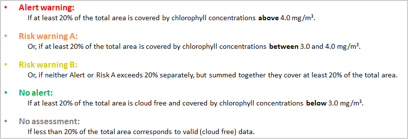
User defined criteria and thresholds for generation of warnings in the Baltic Proper example.
Based on the user defined locations or areas, criteria and thresholds, near-real time “Alerts” are automatically generated from the satellite based water quality information and sent to the User as text messages and maps.
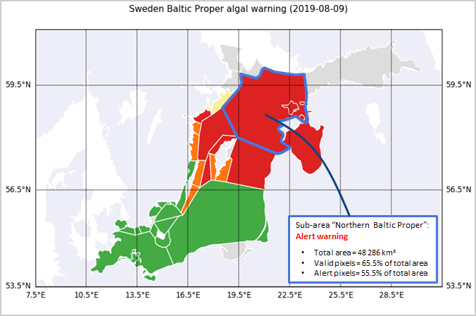
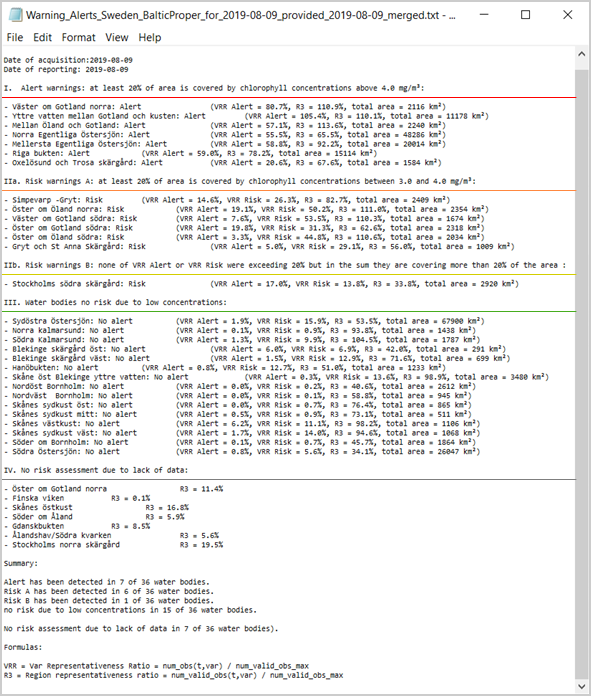
An example of warnings for the Baltic Proper.
|
Obtain the latest information and report your own observations in the CyanoAlert App |
|
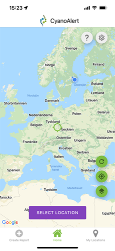
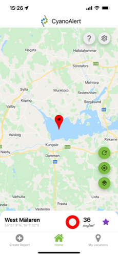
Zoom to your water of interest and select a location |
|
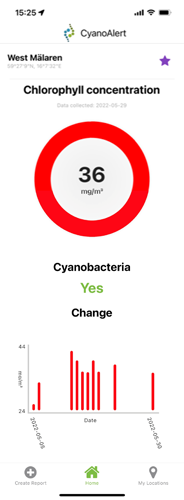
Receive information about chlorophyll level and trend, and indication about cyanobacteria presence |
|
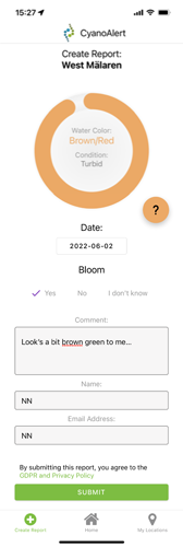
Report your observations to the CyanoAlert team and other App users |
|
|
|
|
|
|
Disclaimer: The CyanoAlert App is an experimental mobile application and provides satellite-based water quality information, which is not routinely quality assured and should be, therefore, considered a research level tool.
The development of this service received funding between 2016-2020 from the European Union's Horizon 2020 research and innovation programme under grant agreement No 730141.
INCDDD is a research autonomous legal entity organization and a non-profit organization having a number of employees smaller than 250, an annual turnover smaller than 50 million euro and the total balance sheet is smaller than 43 million euro. INCDDD carries out basic and applied research to scientifically support the management in the Danube Delta Biosphere Reserve and other wetlands of national and international importance for the biodiversity conservation and sustainable development. The main activity: evaluation of structure and function of the aquatic ecosystems; monitoring of the biological diversity and environmental factors; modelling the processes that are the basis of ecosystem functioning are focused on implementing the international environmental conventions in Romania; consultancy for harmonizing the Romania’s legislation with the EU policy related to environmental protection; strategies for biodiversity conservation and sustainable use of the natural resources (fish, vegetation, game and landscape); assessment and reduction of the human impact; restoration and rehabilitation of the ecosystems that have been injured by the negative human activity. INCDDD has databases with elements of the following issues: cyanobacteria, phytoplankton, chlorophyll a, algal biomass.
The Information Centre for the Baltic Proper (Infobaltic, IB) is a part of the County Administrative Board (CAB) of Stockholm, which is a Swedish national authority. There are 21 CABs in Sweden. The CAB is a link between people and the municipalities on the one hand, and between the government, parliament and national authorities on the other. It is a coordinating national authority with supervisory responsibilities and also a public service authority. Sweden has three Information Centres, hosted at three different CABs, whose primary purpose is to monitor large-scale events in the marine environment. This may involve, for example algal blooms, oxygen depletion, or cases of larger numbers of dead birds, fish or seals. IB monitors the area from the Åland Sea to the Sound (except the Gulf of Finland and Gulf of Riga). IB receives information from a large number of sampling points included in national and international monitoring programs and they cooperate with more than twenty agencies, research institutions and other organisations/companies that are active in monitoring the Baltic Sea environment, both within and outside Sweden. Annual reports are published and information on on-going events is distributed to the public. IB receives 100-150 requests for information, mainly focused on algal blooms, every year. A majority of the requests comes for media and single statements have shown to have a large spread in local/regional media.
ISS conducts scientific research in a wide variety of fields, from cutting-edge molecular and genetic research to population-based studies of risk factors for disease and disability. Research priorities are based on those set forth in the National Health Plan. The Institute is also involved in several major clinical trials, which are frequently conducted in cooperation with the Scientific Institutes for Research and Care (IRCCS) network and Hospitals. Among its activities, it monitors trends in disease, mortality and other health factors and provides technical support for health-related environmental surveys and for investigations of epidemics and other public health problems at national, regional and local level. It also supervises the laboratories engaged in the testing of prohibited substances in sport and the national veterinary institutes. Finally, it has an important role in monitoring and coordinating blood transfusion services and plasma production in Italy. The research group for environmental quality and fish farming (Qualità Ambientale e Ittiocultura, QAI) is part of ISS’ Department for Environment and Primary Prevention (Ambiente e Connessa Prevenzione Primaria, AMPP). It consists of multidisciplinary experts who deal with the health of aquatic ecosystems (natural, artificial and urban), environmental quality and fish farming, through the study of microbiological, chemical and physical, chemical, biological (indicators biological and toxic algae), ecotoxicology, molecular, cartographic (GIS), management and sanitation for the prevention of effects on human and animal health (fish farming) and the health and environmental risk assessment.
If you are new to CyanoAlert and have questions regarding products and services, please contact info@cyanoalert.com
If you need support as a registered CyanoAlert user, please contact support@cyanoalert.com